44408IRE
INTRODUCTION: The Ring of Kerry is a 111 Mile (179km) Road Loop that begins and concludes in the town of Killarney, Co Kerry. A Ring of Kerry Day Trip is all about the majesty of the landscape, which varies dramatically as visitors travel around the Ring. The Ring of Kerry is one of three peninsulas that jut out into the Atlantic Ocean on the South Western Seaboard of Ireland. The three peninsulas are: The Dingle Peninsula to the North, the Iveragh (Ring of Kerry) Peninsula in the Centre and the Beara Peninsula to the South. A Ring of Kerry journey is dominated by the MacGillycuddy Reeks (Mountains) and these mountains, with the highest peak being Carrauntoohil, greet the traveller as they depart Killarney in the morning and also when they arrive back in Killarney in the mid to late afternoon.
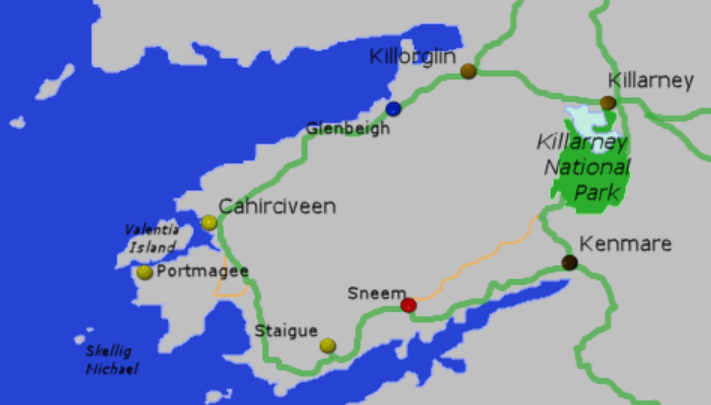
ROUTE: The traditional route for Tour Buses travelling the Ring of Kerry is to travel anti-clockwise, using the R562 out of Killarney to Killorglin, joining the N70 which loops around the Peninsula, via Waterville until reaching Sneem. At Sneem the R568 can be used through the heart of the mountains to Molls Gap where it joins the N71 from Kenmare (or if time is of no object, then continue along the N70 to Kenmare and join the N71). The N71 travels down through the Killarney National Park and back into Killarney.
WEATHER: The Ring of Kerry is all about the weather. Even if it is pouring with rain in Killarney in the morning, that does not mean that it is pouring with rain in Waterville on the Atlantic Shore at the same moment or will be later on in the day. The Ring of Kerry seems to have a weather pattern of its own, and that is part of its beauty and appeal. To travel the Ring of Kerry is to play the weather and the aim of travelling the Ring is to incorporate the weather as an integral part of the journey and experience.
TIME: The length of time spent on the Ring of Kerry all depends upon how many stops are made whilst travelling the Ring and these stops often depend upon the weather. On average a Ring of Kerry journey with varied stops and lunch can take five to six hours.
TOILETS: The Red Fox Inn offers restrooms and refreshments. The Inn is 45 minutes outside Killarney and is a potential stop when taking into account the full Irish breakfast that has been consumed, they can also visit the Kerry Bog Village if time. Glenbeigh Sheep Show has toilets in the adjacent shop/pub. Waterville has public toilets in the coach park, which is opposite the Butlers Arms Hotel and Sneem has public toilets on the left hand side as you come into the village, before crossing the bridge. Avoca Craft Shop, Muckross House and Ross Castle all have toilets on site.
LANDSCAPE: The Ring of Kerry is centrally dominated by the MacGillycuddy Reeks (Mountains), to its north lies Dingle Bay, at its western point the Ring opens up onto the Atlantic Ocean at Waterville and to the south the Ring follows the Kenmare River (Bay). The R568 at Sneem brings the visitor into the heart of the mountainous landscape and upon joining the N71 at Molls Gap, the journey continues down through ancient woodland and a three lake dominated landscape. The Ring of Kerry is very much a glacially shaped landscape. The Gap of Dunloe is a key geographical feature on the Ring and is seen slicing through the mountains on the road to Killorglin in the morning and once again on the journey from Molls Gap, back down into Killarney in the afternoon.
VISITOR ATTRACTIONS WITH AN ENTRANCE FEE: The Ring of Kerry is very much about landscape but as with all tourist routes there are a number of visitor attractions that can, time and group permitting be squeezed into a day trip. At the Red Fox Inn, outside Killorglin, there is a Bog Village. This attraction recreates residential and business dwellings of the 19th century and includes Bog Ponies and Burning Turf Fires. The Ring of Kerry has two Sheep Dog Demonstrations. The first is located at Glenbeigh, on the northern side of the Peninsula and the second is located at Kissane on the southern side. These demonstrations are run by working farmers, are roughly 30 minutes in duration and are strictly seasonal.
SHOPPING: The Ring of Kerry has various shopping opportunities and these are listed in an anti-clockwise direction. Mackens of Ireland is on the R562 to Killorglin, Pat’s Craft Shop is situated at Kells on the N70, Waterville Craft Market is situated on the N70 entering Waterville, Quills Woollen Store is located in the centre of Sneem, the Avoca Craft Shop is located where the R568 and N71 join at Molls Gap and there is a Craft Shop at Muckross House off the N71 heading into Killarney.
WALKING: The Ring of Kerry is not just a driven day trip and at 200kms in length, The Kerry Way Walk, can take up to eight days to complete. The Kerry Way follows a similar route to a Ring of Kerry day trip by coach, but it follows tarmac roads, old railway lines, mountain passes, small paths ‘boreens’, grassed over coach roads and cuts through forestry, farmland and bogland.
PHOTO STOPS: A successful day out on the Ring of Kerry often depends upon the quality of the Photo Stops and very importantly they allow the group to stretch their legs and feel the, often, bracing nature of the weather. Key Photo Stops in an anti-clockwise direction are:
AGHADOE HEIGHTS: Aghadoe is a short diversion at the beginning of the Ring of Kerry route and allows a view that is stunning. At Aghadoe there is an ancient churchyard, with the remains of two round towers. The viewing point offers a panoramic sweep of Lough Leane and the Killarney National Park.
CARAGH BRIDGE: A short way past the Red Fox Inn is a stop that allows a photo of the rugged landscape and the Caragh River. At this point there is often a turf laden donkey awaiting a photo.
KELLS BAY: Along the shoreline there are a number of stops that offer a sweeping view of Dingle Bay and the Dingle Peninsula. On a good day the far western point of the Dingle Peninsula can be viewed and also the Blasket Islands. These islands are famous for their Gaelic language literature and have been uninhabited since 1953.
WATERVILLE BEACH: Adjacent to the Butler’s Arms Hotel in Waterville is a coach park with toilets. This is a great place for people to have some quality time with the Atlantic Ocean. The view is stunning and there are plenty of stones to skip upon the incoming tide.
COOMAKISTA PASS: The climb up to this viewing point allows a very tight over the shoulder view out towards Skellig Michael. The Skelligs are pinnacles of rock that were the site of a Christian Community during Celtic times. The viewing point at the top of the Coomakista Pass offers a view back down into Waterville and also south, towards the Beara Peninsula and Kenmare River (Bay).
CASTLECOVE: Castlecove has a small stop that when the sea is rough offers views of crashing waves against the rocks.
LADIES VIEW: Ladies View is the classic photo stop looking down towards Killarney with the three lakes, Upper, Middle and Lower (Lough Leane) in between. Ladies View takes its name from Queen Victoria’s Ladies in Waiting who enjoyed the view when Queen Victoria visited Killarney in 1861. Ladies View can be busy and within a short distance are two other photo stops, each offering a similar vista.
TORC WATERFALL: A visit to Torc Waterfall is an option if the weather has been dry. There are only two coach spaces, so not to promise is a good idea as often you cannot get parked. The Waterfall is a ten minute walk.
MUCKROSS HOUSE: Muckross House offers a car park, toilets and café and allows the chance for photos out across Lough Leane.
ROSS CASTLE: Ross Castle is a potential photo stop when returning into Killarney. The Castle can be reached along Ross Road, off the N71 coming into the centre of Killarney. Ross Castle is situated directly on the banks of Lough Leane.
A BAD WEATHER CHEAT: If the weather forecast is atrocious for the Ring in the morning but looks like it might clear, then all is not lost. There is what is called the ‘Mini Ring’, which takes you via Kenmare. The routing is the N22 South, then the R569 towards Kenmare. Kenmare is a market town and is well worth some time spent. There is a Stone Circle on the outskirts of the town. The N71 brings to you up to Molls Gap and the Avoca Craft Store, which then winds down via Ladies View and the Killarney National Park back into Killarney.
TOWNS, VILLAGES AND SIGHTS ALONG THE ROUTE OF THE RING OF KERRY: All listed in an anti-clockwise manner.
AGDAHOE (Acha Da Eo-The Place of the Two Yew Trees): Romanesque Style Monastic Ruins made up of a church and two round towers. There are views of Lough Leane and the National Park.
BEAUFORT: Beaufort is on the outskirts of Killarney and offers views towards the MacGillycuddy Reeks and The Gap of Dunloe. The Gap of Dunloe is a glacial valley and also a pass that links the North of the Peninsula with the Lakes of Killarney to the South. It is a classic Pony and Trap Route and has Kate Kearney’s Cottage as one of its key visitor attractions.
KILLORGLIN (Cill Orglan- Orgla’s Church): Killorglin is seen as the gateway to the Iveragh Peninsula and the town overlooks the Laune River. Upon reaching the stone bridge over the river, there is on the left, a statue of a Wild Mountain Goat known as King Puck. The Puck Fair takes place in mid-August and is seen as a Pre Christian fertility festival.
GLENBEIGH (Gleann Beithe-Valley of the Beech Trees): Glenbeigh is nestled at the foot of a wooded mountain and is close to the head of Dingle Bay. The Kerry Bog Village at the Red Fox Inn is located close to Glenbeigh.
GLENCAR: The Caragh Lake and river at Glencar are key spots for anglers. Wynn’s Folly, a castellated ruined mansion built in 1867 can be seen on the road to Kells.
ROSSBEIGH: Rossbeigh offers 6.5kms of golden sand beach.
KELLS: The stretch of road at Kells offers panoramic views of Dingle Bay, the Blasket Islands and Kells Bay. Fungie the Dolphin will be over towards Dingle Town. At this point the road passes the Drung Hill Tunnels and the Gleensk Viaduct, both relics of the Great Southern and Western Railway. There is a proposal to turn the old railway route into a cycle track.
CAHERSIVEEN (Cathair Saidhbhin-Little Saidhbh’s Stone Fort): Cahersiveen is situated at the head of Valentia Harbour on the Fertha River. The town is the main shopping area on the western end of the Peninsula. On the outskirts of Cahersiveen are the ruined birth place of the 19th Century Irish Catholic Liberator Daniel O’Connell and a monument to St Brendan the Navigator, who set off on his Atlantic Journey from this point in the 6th Century. Cahersiveen’s church is named in honour of Daniel O’Connell, the old Military Barracks has a heritage centre and on the Northern Side of the Fertha River are Ballycarbery Castle and Lecanabuaile Fort.
AT THIS POINT THE TRADITIONAL RING OF KERRY TOURIST COACH ROUTE FOLLOWS THE N70 TO WATERVILLE, BUT THE IVERAGH PENINSULA CONTINUES WESTWARDS. THE KEY TOWN, VILLAGES AND SIGHTS ARE PORTMAGEE, VALENTIA ISLAND AND THE GLEN.
PORTMAGEE (Port Mhig Aoidh-Magee’s Harbour): A fishing village that offers boat trips to Skellig Michael. At Portmagee a modern bridge crosses over to Valentia Island.
VALENTIA ISLAND (Beal Inse-The Mouth of the Rivers): Valentia is an island of scenic beauty, tropical vegetation, cliffs and seascapes. The Skellig Experience visitor centre is located on the island, as is a slate quarry which provided the slate for the roof of the Houses of Parliament. The first transatlantic telegraph cable connecting Europe and America was laid from Valentia.
THE GLEN/BALLINSKELLIGS: The Glen is an Irish speaking area, with a Gaelic Summer Language School. To the south west of the village is Bolus Head which overlooks St Finan’s Bay and the Skelligs.
From Cahersiveen the N70 continues onto Waterville through an area of Turf Bog and a Gaelic Speaking Area ((Gaeltacht).
WATERVILLE (An Coirean-The Little Whirlpool): Waterville nestles between Lough Currane and the Atlantic Ocean. Waterville has statues to Charlie Chaplin, who holidayed here and one that celebrates County Kerry’s great Gaelic Football heritage. Waterville is connected to St Finan who had an oratory at Lough Currane and there are Standing Stones reputably connected to the Milesian Invaders of Ireland. Waterville has various restaurants and eateries.
THE SKELLIGS: After Waterville the N70 climbs up to the Coomakista Pass summit. The pass is where legend says that treasure is buried from a Spanish Armada 1588 shipwreck. Climbing the pass offers views out towards the Skelligs. These pinnacles of rock, Skellig Michael and Little Skellig, rise 220 and 200 metres out of the Atlantic Ocean. On Skellig Michael can be found the remains of a Celtic Christian settlement high up on a series of rock terraces, with stone steps to reach them carved into the rock by Celtic Monks. Little Skellig is a breeding ground for Gannets and often shimmers white in the sunlight from the Gannet Guano. Star Wars Episodes VII and VIII were filmed on Skellig Michael, with the island closed off to the public during filming.
CAHERDANIEL (Cathair Donaill-Donal’s Stone Fort): Caherdaniel stands on Derrynane Bay and from the road a ruined Ring Fort can be seen. Derrynane House, once the home of the Catholic Liberator Daniel O’Connell was where he lived and worked during his political life. The house and grounds are open to the public.
CASTLECOVE (An Siopa Dubh-The Black Shop): Castlecove is a small beach resort on the Kenmare River (Bay) with sandy beaches. Nearby, but not accessible by coach is Staigue Fort. The Fort is one of the finest examples of a stone fort in Ireland and is 2,500 years old.
SNEEM (An tSnaidham-The Knot): Sneem is situated on the estuary of the Ardsheelaun River. Sneem is a key stopping point on the Ring of Kerry and has won awards as one of ‘Ireland’s Tidy Towns’. Sneem is big on public art and has monuments dedicated to French President Charles the Gaulle, to Irish President Cahill O’Daley and the local sporting family, the Casey’s.
AT THIS POINT THE MORE DIRECT ROUTE IS TO FOLLOW THE R568 THROUGH THE HEART OF THE MOUNTAINS AND JOIN THE N71 AT MOLLS GAP. TO CONTINUE ALONG THE N70 BRINGS TRAVELLERS TO PARKNASILLA AND KENMARE.
PARKNASILLA (Pairc na Saileach-The Willow Field): Parknasilla is situated in a sheltered spot on the coastline of the Kenmare River (Bay). Its position and the effects of the Gulf Stream allow subtropical plants and vegetation to grow.
KENMARE (Neidin- The Little Nest): Kenmare is situated at the point where the River Roughty opens into the estuary of the Kenmare River. The town was founded in 1670 by Sir William Petty on land assigned to him by the English Government. Kenmare has a history of lace making and has a prehistoric stone circle and a holy well both within a five minute walk of the town green.
The R568 passes through a mountain landscape of steep slopes, glacial tarns and changing vistas. The N71 is joined at Molls Gap and from there the road descends through the Killarney National Park, past the Upper, Middle and Lower Lakes and the Muckross House Estate to Killarney.
MOLL’S GAP: Moll’s Gap takes its name from Moll Kissane who ran a shibeen (an unlicensed public house) in the 1820’s, when the road was being constructed.
KILLARNEY NATIONAL PARK: The Killarney National Park has its foundations in 1932 in a gift to the Irish State of 4,000 hectares by the Bowers Bourn family, owners of Muckross House. Today the National Park is 10,289 hectares in size and comprises the mountains and woodlands which surround the Lakes of Killarney, as well as the Lakes themselves. The National Park includes the peaks of Mangerton, Torc, Shehy and the Purple Mountains. The Park show traces of Copper Mining from 4,500 years ago, has connections to one of Ireland’s most important books, The Annals of Innisfallen and is home to an 850 strong herd of native Irish Red Deer. The N71 passes through ancient woodland that comprises of Sessile Oak, Holly, Alder, Arbutus and Yew.
MUCKROSS HOUSE AND ESTATE: (Mhucrois-Place of the Pigs): Muckross House and Estate was originally part of the now ruined Muckross Abbey, which was founded in 1448 and finally closed during the time of Oliver Cromwell in the 16th century. The Abbey ruins are a 20 minute walk from the main 19th century house. Muckross House dates from 1843 and was originally in the ownership of the Herbert Family. A Member of the Guinness Family purchased the house and estate in 1899 and in 1910 a wealthy American, William Bowers Bourn, took over the ownership of the house and gave it to his daughter Grace as a wedding gift.
ROSS CASTLE: Ross Castle, situated upon the banks of Lough Leane, is built in the tower house style and dates back to the 15th Century, when it was constructed by the O’Donoghue Clan. In the 17th Century it belonged to the MacCarthy Mor family and finally the Brownes, who built nearby Kenmare House.
KILLARNEY (Cill Airne-Church of the Sloe): Killarney was the site of a Celtic Christian Community, with the 19th century Church of Ireland Church of St Mary’s marking that location. Modern Killarney owes its growth and importance to the growing Romantic Movement in the 18th Century. By 1756 Killarney was on the map as an excellent starting point from which to explore the surrounding landscape. Killarney is essentially one street, Main Street, with other smaller streets branching off it. The most visible building in Killarney is St Mary’s Catholic Cathedral. St Mary’s Neo Gothic Cathedral was designed by Augustus Pugin, its foundation stone was laid in 1842, with construction halted during the Potato Famine of the mid to late 1840’s. The Cathedral was consecrated in 1855 and close by to the West Door a tree marks the spot of a famine graveyard.
CONCLUSION: The Ring of Kerry should not just be seen as a drive. The Ring of Kerry offers up some wonderful changing and shifting landscapes, it can sometimes have all four seasons in one day and it contains some great connections to Irish history and mythology. There is no ‘Ring’ to be reached and ultimately a day trip is not about one aspect it is about everything that goes into making up the Ring of Kerry. The Ring is all about a sense of discovery.